On , 6 July 2002 (AS 36), Lochac became the 17th Kingdom in the Known World of the Society for Creative Anachronism (SCA). However, there are currently 20 Kingdoms in total.
Lochac is one of only two Kingdoms that rule the southern hemisphere (the other being Drachenwald), and currently comprises the entirety of Australia, New Zealand, the Antarctic Territories and the Bass Strait, making it the Kingdom governing the largest land/sea area in the SCA. She is also the only Kingdom in the Known World that was born from two parent Kingdoms – The West Kingdom and the Kingdom of Caid.
Origins of the Names of Lochac
Kingdom of Cumberland (1980)
Before Australia and New Zealand officially joined the SCA, a group of medieval enthusiasts in Sydney (New South Wales, Australia) joined together in 1980 to form the Kingdom of Cumberland. It was so named after the Cumberland Plateau – the geographical region upon which the group lived.
Outrémer (1981)
In 1981, the Australian medieval group became affiliated with the SCA and changed their name to Outrémer (pronounced oo-tra-meer). Parentless, it was declared a Marche Barony and the members were tasked with going Kingdom Shopping to choose a parent Kingdom to oversee their group.
Lochac (mid-1980’s)
By the time the Australian branches of the SCA were ready to ascend to a Crown Principality of the Kingdom of the West in 1985, the group name was changed from Outrémer (which wasn’t able to be registered) to Lochac (pronounced locally as lock-ark).
Members were encouraged to make submissions for name proposals, with eight historical, and six other, names put to a member referendum. These names included:
- Lochac/Luchach – 1250 – Marco Polo;
- Regio Patalis (‘Nether Regions’) – 1523;
- Terra Australis (‘Land of the South’) – 1531;
- Boeach (mistranslation of Luchach) – 1532;
- Java La Grande – 1550;
- Notasia (‘South of Asia’);
- Maletur (mistranslation of Marco Polo’s Malaya);
- Beach (short form of Boeach) – 1570;
- Continens Australis – 1570;
- Terra Australis Incognita (‘unknown South land’);
- Terra Incognita (‘unknown land’);
- Australis Incognita (‘unknown South’);
- Southern Region;
- Southmost Region; and
- Region of Rowany.
Alexandro d’Argenteria discovered the winning name “Lochac” in a book of Marco Polo’s travels. It is based on one of the names that the Chinese used to call this southern region, as transcribed by Marco Polo.
When the New Zealand branches joined the Australian branches of the SCA in 2003, the name of Lochac was retained. The name refers to the entire Kingdom – including all of Australia, New Zealand, and Antarctica.
Groups of Lochac
The Kingdom of Lochac currently comprises 40 subgroups, including 12 Baronies, 10 Cantons, 8 Shires, and 10 Colleges.
Regents of Lochac
As at December 2015 (AS 50), the Kingdom of Lochac has been overseen by 27 reigns of Kings and Queens, 36 reigns of Princes and Princesses, and 5 reigns of Viceroys and Vicereigns.
Landed Gentry of Lochac
As at October 2014 (AS 49), the Baronies of Lochac have been overseen, on behalf of the Regents, by 73 tenures by 67 Barons, 69 Baronesses and 4 Vicars.
Regions of Lochac
In addition to the groups of Lochac, the Kingdom includes several other regions.
Crescent Isles
The Crescent Isles is the name given to the collective groups of Lochac situated in New Zealand, including the Baronies of Southron Gaard and Ildhafn, the Canton of Cluain and the Shire of Darton.
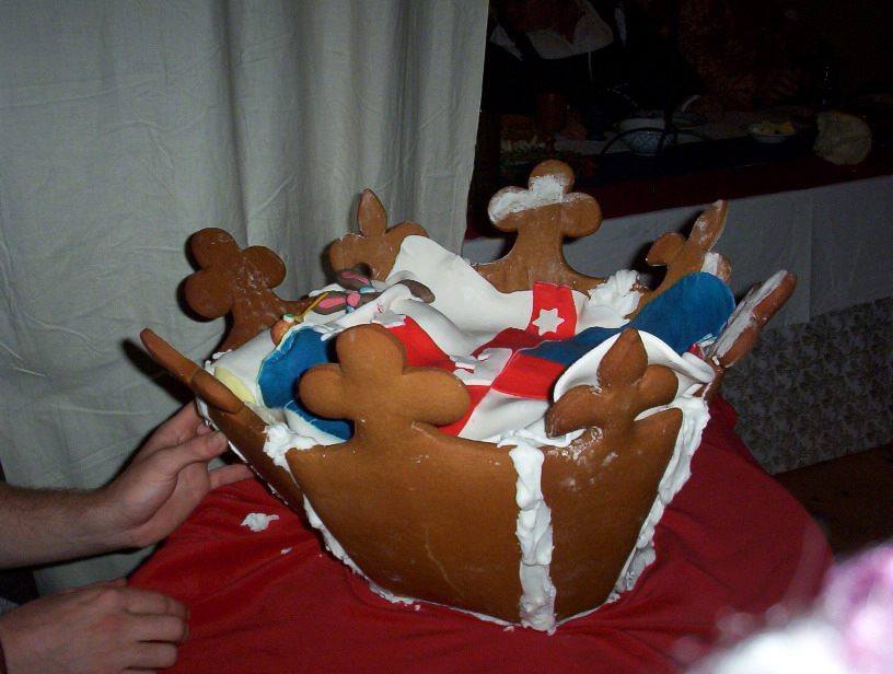
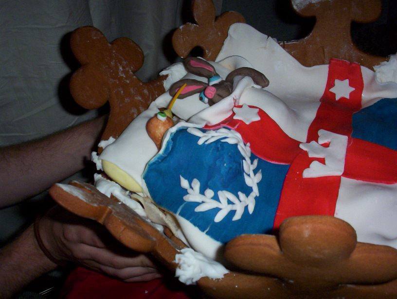
It was announced at May Crown 2003 in the Shire of Arrowreach that the Crescent Isles, formerly of the Kingdom of Caid, were to join Lochac. At this event a soteltie was presented to celebrate the occasion, made by Catherine of Arrowsreach.The soteltie was a gingerbread crown filled with gingerbread North and South islands (NZ), Ynys Fawrs (Tasmania) and Terra Rosa (mainland Australia), hidden under a doona with the Lochac device and a kangaroo and a kiwi resting their heads on little pillows.
Great White Southern Land (see also Ynys Rhew)
The Great White Southern Land is the name given to the non-Australian territories of Antarctica, claimed by the Barony of Southron Gaard.
Northern Reaches
The Northern Reaches is the name given to the collective groups of Lochac located in Queensland, including the Baronies of River Haven and Saint-Florian-de-la-rivière, the Cantons of Burnfield and Stegby, and the Shire of Willoughby Vale.
Terra Rosa
Mainland Australia is sometimes referred to as Terra Rosa.
Ynys Rhew (see also Great White Southern Land)
Ynys Rhew means the Ice Isle. It is the name given to the Australian territories of Antarctica. The area from the South Pole to Tasmania, including the Bass Strait, are claimed by the Barony of Ynys Fawr.
There have been several disputes over the ownership of Ynys Rhew (including from the Kingdom of Caid in December 1992 and again in October 2014; and from the Kingdom of Atlantia), however, as Lochac was the first group in the SCA to register their claim it remains a part of Lochac.
On the weekend of 5-6 December, AS 27, the Principality of Lochac (still part of the Kingdom of the West at the time) and the Barony of Southron Gaard (still part of the Kingdom of Caid at the time), fought the SCA´s first inter-Kingdom battle in the Southern Hemisphere, involving participants from both the mainland Kingdoms as well as the local groups. The event, held in Southron Gaard, was called the Pen Gwynne War and was fought over the ownership of Antarctica/the Great White Southern Land. Southron Gaard were the eventual winners, collecting all five battle pennants but donating one to the worthy combatants from Lochac and the West.
At Rowany Festival in A.S. 41, the forces of the groups from the Crescent Isles (now part of the Kingdom of Lochac) and their allies met those of the Barony of Ynys Fawr and its allies to yet again contest the ownership of the Great White Southern land/Ynys Rhew. The Crescent Isles were victorious and, as a reward, the founding Baron of Ynys Fawr (Hrölf Herjölfssen) was gifted to the Baron and Baroness of Southron Gaard as an honorary citizen of their fair lands.
A monograph outlining the details of the first Pen Gwynne War is available on Mistress Katherine Kerr of the Hermitage’s website.
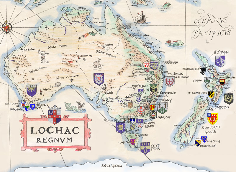
Maps of Lochac
There have been many maps of Lochac drawn/painted over the years.
Possibly the earliest map of Lochac, drawn around the time Lochac was proclaimed a Crown Principality of the West Kingdom, was published in the 10th issue of the newsletter Runes.

A map of the Principality of Lochac was commissioned by Prince Cornelius von Becke as a gift for the King of the West. The map does not include the whole of Australia because there were no SCA groups in those areas at the time of production. New Zealand is included in the map with the words ‘Conquered lands’, which may have caused a small uproar between the West Kingdom (who oversaw Australia at the time) and the Kingdom of Caid (who oversaw New Zealand at the time).
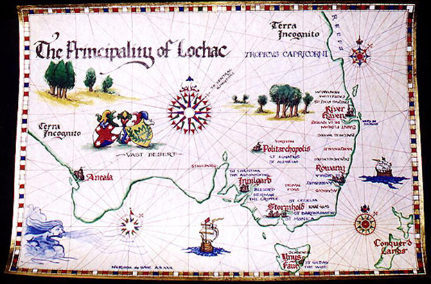
A slightly outdated map of the more recent structure of the Kingdom of Lochac can be found on the Kingdom website: Mappe of the SCA Kingdom of Lochac (image below).